Rare Book Monthly
Book Catalogue Reviews - December - 2010 Issue
Fine Antique Maps from Jonathan Potter Limited
The Pacific Ocean, bounded by an enormous southern continent.
Item 148 is a C. Flemming German reissue of the map of Texas originally published by John Arrowsmith. This shows Texas during its brief republic period (dated 1845). The printing in Germany is significant as this was the time when German immigrants were encouraged to come to Texas. The Texas German community of New Braunfels was established in that year, Fredericksburg the following year. £1,500 (US $2,390).
Item 285 is one of those combination cartoons and maps, and a very political one at that. The heading is An Eclipse. Lately Discovered In The Georgium Sidus, And Quite Unexpected By Any Of The Astronomers. The date of this lithograph is 1829; the creator "A. Sharpshooter." It depicts the sun as the face of King George IV, almost blotted out by the moon, containing the face of the Duke of Wellington, then serving as Prime Minister. Wellington's eclipse of George casts a long shadow on the Earth, covering England in particular. However, Ireland continues to enjoy the bright sunlight. In 1829, Parliament passed the Catholic Relief Act, with Wellington being the prime promoter and the one who put pressure on George to go along. The Act enabled Catholics to serve in Parliament. That was particularly welcome by Catholic Ireland. One can guess that Mr. "Sharpshooter" was perhaps less than pleased with this development. £400 (US $637).
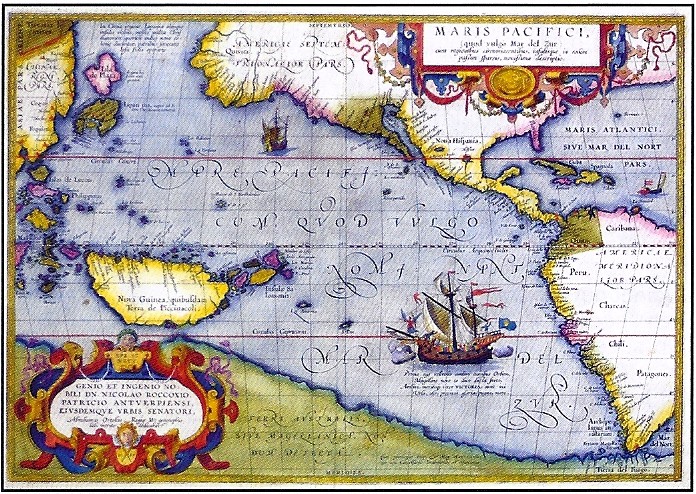
Item 108 is an Ortelius map, originally published in 1590, and taken from his Spanish language atlas of 1612. It displays the Pacific Ocean, and the lands surrounding it. The Americas and the coast of Asia are reasonable enough for the time, but the island of New Guinea is way outsized for reality, and most notable is the presence of the great southern continent. Anyone wondering why Cook's discovery almost two centuries later that there was no great southern continent was so significant need only look at this map. It runs all the way from the tip of South America to just south of New Guinea, and this is just the Pacific portion of this enormous, though unreal continent. £7,500 (US $11,956).
Jonathan Potter Limited may be reached at [email protected] or +44 (0)20 7491 3520. The website is found at www.jpmaps.co.uk.
Rare Book Monthly
-


Dominic Winter Auctioneers
Printed Books, Maps & Wisdens, English Bibles
1500-1800
22nd July 2026Dominic Winter, July 22: Lot 83 – Westall & Owen. Picturesque Tour of the River Thames, 1st edition, 1828. £2,000-3,000.Dominic Winter, July 22: Lot 88 – Blume. Rumphia, Botanicae de plantis Indiae Orientalis, 1835-1848. £2,000-3,000.Dominic Winter, July 22: Lot 101 – Michaux. Histoire des arbres forestiers de l'Amérique septentrionale, 1810-1812. £700-1,000.Dominic Winter Auctioneers
Printed Books, Maps & Wisdens, English Bibles
1500-1800
22nd July 2026Dominic Winter, July 22: Lot 102 – Miller & Shaw. Cimelia Physica, 1796 [but c. 1816]. £3,000-5,000.Dominic Winter, July 22: Lot 104 – Parkinson. Theatrum Botanicum: The Theater of Plants, London: Thomas Cotes, 1640. £800-1,200.Dominic Winter, July 22: Lot 159 – Plancius. Orbis Terrarum..., double hemisphere map, 1594-99. £5,000-8,000.Dominic Winter Auctioneers
Printed Books, Maps & Wisdens, English Bibles
1500-1800
22nd July 2026Dominic Winter, July 22: Lot 217 – Illuminated Medieval Manuscript. From a Breviary, 14th/15th c. £3,000-4,000.Dominic Winter, July 22: Lot 224 – The newe Testament … By Wylliam Tyndall…, 1549. £3,000-5,000.Dominic Winter, July 22: Lot 238 – Douay-Rheims Bible. 3 volumes, 1582/1609/1610. £7,000-10,000.Dominic Winter Auctioneers
Printed Books, Maps & Wisdens, English Bibles
1500-1800
22nd July 2026Dominic Winter, July 22: Lot 336 – Ashendene Press. A Treatyse of Fysshynge with an Angle, 1903. £1,000-1,500.Dominic Winter, July 22: Lot 393 – Sassoon. Memoirs of an Infantry Officer, signed limited edition, 1931. £800-1,200.Dominic Winter, July 22: Lot 402 – Dylan Thomas. Twenty-Five Poems, 1st edition in d.j., 1936. £400-600. -


-


. <I>A New boke of the natures and properties of all wines that are commonly vsed here in England,</I> rare first edition of the first English book on wine, By William Seres, 1568. £20,000-£30,000")
. <I>The Faerie Queene.</I> first edition, Printed [by John Wolfe] for William Ponsonbie, 1590. £30,000-40,000")
. <I>The Comedie of Errors,</I> extracted from the first folio, Isaac Jaggard and Edward Blount, 1623. £15,000-20,000")

. <I>Casino Royale,</I> first edition, signed presentation inscription from the author, 1953. £40,000-60,000")
. <I>Anatomie de la Tête,</I> first edition, Paris, chez le Sieur Gautier, 1748. £10,000-15,000")
. 'Praying Mantis style' Kung Fu book, containing numerous annotations, diagrams and graphs in Bruce Lee's hand, c. 1960. £50,000-70,000")

. <I>Sketches in North America and the Oregon Territory,</I> first edition, rare hand-coloured issue, 1848. £30,000-40,000")
. <I>The Marine Atlas, or Seaman's Complete Pilot for all the principal places in the known world...,</I> 1826. £30,000-50,000")

Forum Auctions
The 10th Anniversary Sale
Fine Books, Manuscripts and Works on Paper
July 16, 2026Forum, July 16: Inundation papyrus. P.Michael 4, the ‘Inundation papyrus’, a geographical account of the Nile near Canopus, in Greek, remains of two columns from a manuscript scroll on papyrus, Egypt, second century CE. £12,000-18,000Forum, July 16: Book of Hours, use of Sarum, manuscript on vellum, 6 full-page miniatures, with famous Middle English inscriptions, Southern Netherlands for the English market, [c.1430]. £30,000-50,000Forum, July 16: Qu'ran, Arabic manuscript on burnished, stencilled, and gold-flecked paper, 447ff., Sultanate Gujarat, Ahmadabad, [after 1411 but no later than 1442]. £15,000-20,000Forum Auctions
The 10th Anniversary Sale
Fine Books, Manuscripts and Works on Paper
July 16, 2026Forum, July 16: Turner (William). A New boke of the natures and properties of all wines that are commonly vsed here in England, rare first edition of the first English book on wine, By William Seres, 1568. £20,000-£30,000Forum, July 16: Spenser (Edmund). The Faerie Queene. first edition, Printed [by John Wolfe] for William Ponsonbie, 1590. £30,000-40,000Forum, July 16: Shakespeare (William). The Comedie of Errors, extracted from the first folio, Isaac Jaggard and Edward Blount, 1623. £15,000-20,000Forum Auctions
The 10th Anniversary Sale
Fine Books, Manuscripts and Works on Paper
July 16, 2026Forum, July 16: Fleming (Ian). Casino Royale, first edition, signed presentation inscription from the author, 1953. £40,000-60,000Forum, July 16: d'Agoty (Jacques-Fabien Gautier). Anatomie de la Tête, first edition, Paris, chez le Sieur Gautier, 1748. £10,000-15,000Forum, July 16: Martial Arts.- Lee (Bruce). 'Praying Mantis style' Kung Fu book, containing numerous annotations, diagrams and graphs in Bruce Lee's hand, c. 1960. £50,000-70,000Forum Auctions
The 10th Anniversary Sale
Fine Books, Manuscripts and Works on Paper
July 16, 2026Forum, July 16: Warre (Capt. Henry James). Sketches in North America and the Oregon Territory, first edition, rare hand-coloured issue, 1848. £30,000-40,000Forum, July 16: Norie (John William). The Marine Atlas, or Seaman's Complete Pilot for all the principal places in the known world..., 1826. £30,000-50,000Forum, July 16: Mao Tse-tung.- Kim Il-sung.-[Note book for visitors from China to Korea], signed by Mao and Kim, [Beijing, 1954]. £10,000-15,000 -


Case Auctions
2026 Summer Auction
August 1st and 2ndCase Antiques, Aug. 1: Timberlake, Henry: A DRAUGHT OF THE CHEROKEE COUNTRY on the West Side of the Twenty Four Mountains, Commonly Called "Over the Hills". $18,000 to $22,000.Case Antiques, Aug. 1: Manuscript orderly book detailing day to day activities of multiple Virginia regiments in the Continental Army during the Revolutionary,1776-1777. $7,000 to $8,000.Case Antiques, Aug. 1: Cormac McCarthy, The Orchard Keeper, Random House, New York, 1965. Signed 1st Edition. $3,800 to $4,200.Case Auctions
2026 Summer Auction
August 1st and 2ndCase Antiques, Aug. 1: Battle of Kings Mountain Pamphlet by Isaac Shelby, April 1823, Signed. $1,800 to $2,200.Case Antiques, Aug. 1: Large Tintype CSA Lt. Col. Thomas Coke Johnson, 19th GA, w/ Southern Cross, Book. $1,400 to $1,800.Case Antiques, Aug. 1: Rare Civil War Ambrotype, 19th GA Infantry with Johnson Family of GA. $800 to $1,200.Case Auctions
2026 Summer Auction
August 1st and 2ndCase Antiques, Aug. 1: A signed note written by Thomas Alva Edison to an unknown recipient, in which he shares his thoughts on Guglielmo Marconi, regarded as the inventor of the radio. $800 to $1,200.Case Antiques, Aug. 1: Rare 1931 TN Grasslands Steeplechase Book, Gallatin. $800 to $1,000.Case Antiques, Aug. 1: War of 1812 related Broadside, Petersburg Volunteers. $700 to $800.Case Antiques, Aug. 1: 2 World War I Posters, “Our Colored Fighters” and “No Slacker”. $800 to $1,000.