Bordone’s Isolario, Insular Poetry
- by Thibault Ehrengardt
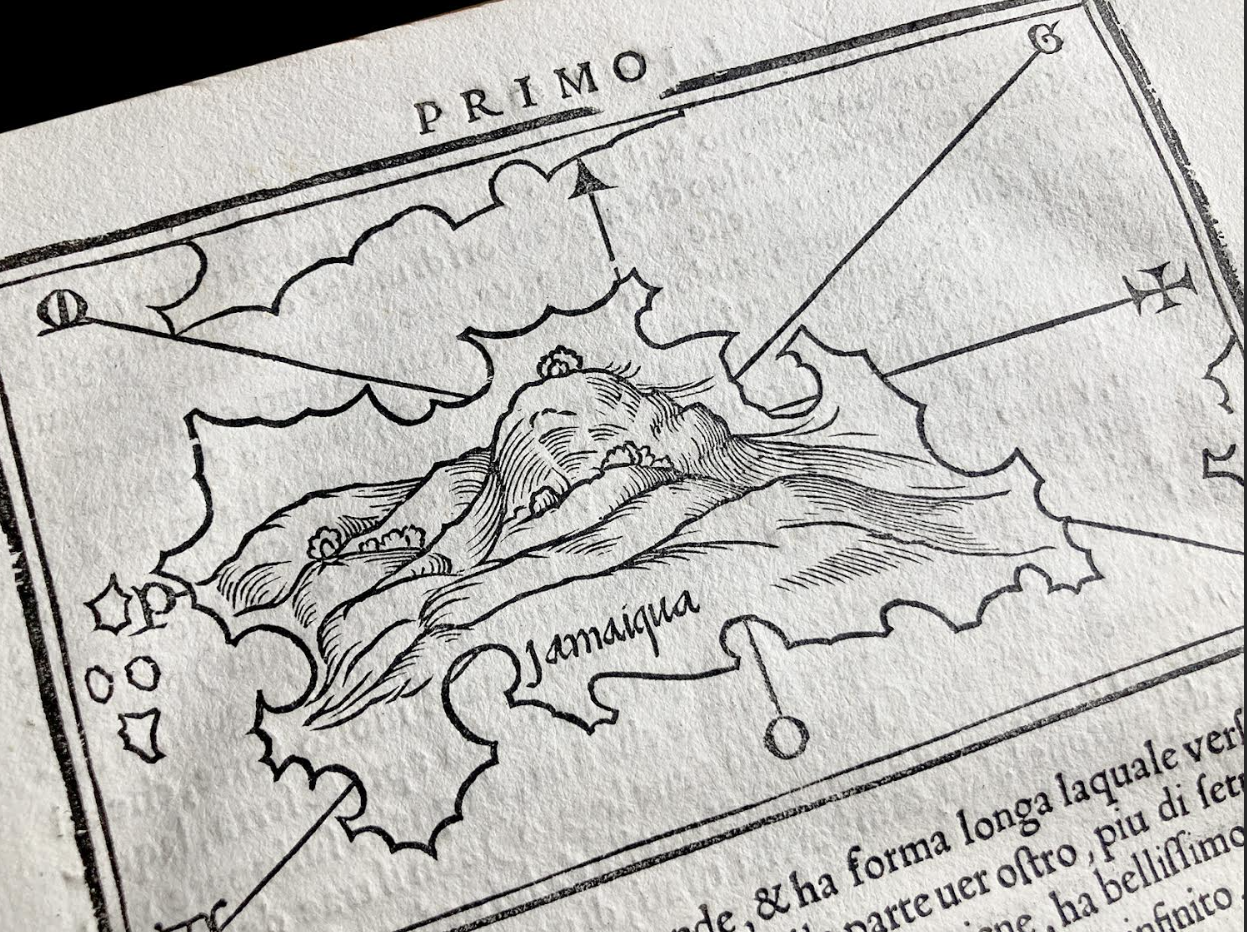
I received a package yesterday that put an end to a 20-year-old quest. At last, I could set my eyes on the first map of the island of Jamaica printed separately! It’s a dreamlike 14.5 cm by 8.5 cm engraving, printed in 1528 in Libro di Benedetto Bordone nel qual si ragiona di tutte l’isole del mondo con li lor nomi antichi & moderni, historie, favole, & modi del loro vivere, & in qual parte del mare stanno, & in qual parallelo & clima giacciono—more conveniently known as Isolario.
When I published a compilation of some early maps of Jamaica (Jamaica Insula), in 2008, I got a digitized copy of Bordone’s map from the National Library of Jamaica (NLJ), which described it as the first map of the island printed separately. Jamaica was granted this honour 104 years after Christopher Columbus first saw it—this is due to the fact that Jamaica didn’t occupy a significant place on the geopolitical chess of the New World until the late 17th century.
This map is included in Bordone’s work (Part XIII of Libro Primo)—but I couldn’t afford such a beautiful book, and had to wait for an isolated map to show up, and at a decent price. This is not a full-page engraving—it’s part of the written description of both Cuba (which map is on the back of the page) and Jamaica. I noticed the binder mark at the bottom, C… and started to wonder. Was I contemplating a genuine map from 1528? Well—yes, and no. Bordone’s Isolario became “one of the most sought-after books during the 16th century,” Sarah Spinella states in her university work*, and as such, was reprinted 3 times in 1534, 1547, and 1565. A digitized copy of the 1528 edition clearly showed that my map comes from a different edition—I wasn’t luckier with the 1534 edition; it turned out that my map actually comes from the 1547 edition. The setting of the letters, and the ill-printed parts of the upper frame of the map leave no doubt about it. So, my map is but a reprint of the very first map of Jamaica printed separately? Fortunately, Götzfried Antic Map informs us that “the maps of all four editions were printed from the same woodblocks in Venice.” A quick comparison confirmed this statement—thank God!
The map itself is a poetic and puzzling representation. The global shape of the island is relatively accurate. So is the position of Cuba and Haiti. Bordone drew a mountain at the centre of the island for the Blue Mountains, I guess—and then added a lot of stylized harbours and some arrows to indicate the directions of the winds (P is for the Ponant, S for the Sirocco etc). There’s no mention of any colony although Melilla, the first Spanish settlement on the North coast was known from the early historians of the New World Bordone borrowed information from; Nueva Sevilla isn’t mentioned either, although it was already thriving—but then again, by 1528, the Spaniards had been in Jamaica for less than 20 years. That’s how close Bordone’s map is to history.
Bordone dedicated his work to his nephew, a professional navigator—but his work was in the true spirit of the Isolari genre, initiated in 1420 by Cristoforo Buondelmonti. Sarah Spinella explains: “The characteristics of the maps and the lack of scale make Isolario almost useless as far as navigating is concerned, as anticipated by the author who claimed he mostly meant to give “alcuno piacevole dilleto” (a certain pleasure) to the readers, and not to the navigators. The success of Isolario resides in an utopian vision of the insular space, beyond exact coordinates.” Bordone featured several islands from the New World, including Jamaica, describing them “in the classic tradition that represents the insular world as a place remote from the logics of the continental reality” (Spinella). No wonder this map is so dreamlike. There’s something infantile about its simplicity and the neatness of its lines that still fascinates. Even Bordone’s contemporaries could feel the difference. “At the time, Europe was rediscovering Ptolemy’s’ Geography—the Aristotelian model was going out of fashion,” Spinella says. Just as the world was to reveal its hidden parts, people hastily populated it with sea monsters, weird human beings, and magical islands. An island being a closed world, it’s a kind of miniaturized world, almost a parable. That’s why Umberto Eco notes in the preface of Bordone’s reprint (2000): “The lands of Utopia are always islands.”
French bookseller Camille Sourget, from Paris, underlines on their website that Isolaria contains “the first printed map of the island of Corsica” (France), as well as the “earliest authentic description of Pizarro’s entry into Peru to appear in a printed book.” Pandolfini, advertising a 1534 copy for sale at auction last year (Rare Book Transaction History) also points out: “The first map of North America printed separately, and the first map of Japan printed in a European book.” No bookseller mentions the first map of Jamaica printed separately, though—guess this commercial argument is still a little bit confusing for regular buyers, just as Bordone’s outlines of the island.
T. Ehrengardt