Panorama of the Hudson River by Wade and Croome
- by Bruce E. McKinney
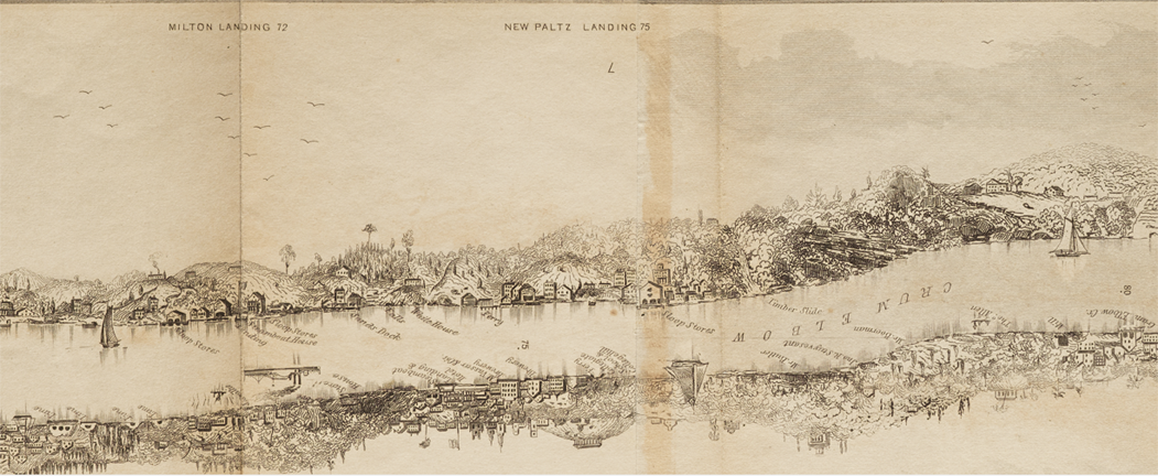
Ulster County from Dutchess County in 1846
Recently I was offered a second edition of Wade & Croome’s Panorama of the Hudson River, printed in 1846. I look to understand the evolving waterfront of the Hudson River during the 19th century and this slim volume provides a remarkably detailed perspective. I bought it at the offered price from Greg Gibson of Ten Pound Island and am very well pleased for the rich detail provided. This version is the plain one that was originally offered for $1.50. Those with more money to spend at the time could buy a hand-colored version for $2.00.
Local histories provide 19th century details and occasionally images but much that I’ve found is somewhat idealized, be it a factory that dwarfs it’s neighbors, dominating it’s neighborhood, or a firm found to be advertising in the back of the book that appears more radiant in the illustrations than other references and images suggest. The key to this book is that no advertising was accepted [or, for all I know, even solicited]. Freed then to portray both banks of the Hudson River between New York City and Albany, the engraver, William Wade, was free to show what he saw and his approach was to provide, in great detail, a perspective that is otherwise difficult to find.
This book, with its 12’ foot by 6” map is packed with details. At a guess somewhere between 1 and 2 thousand buildings, outcroppings and distant points of reference are included and because the perspective is uniform the relative size and significance of places is understandable. For museum, library and historical association presentations, this map, blown up to show its intense detail, is useful and important. Nothing else I’ve seen about the Hudson River in that period is as detailed, and from what I can tell, accurate.
Its current estimated value in the Rare Book Transaction Database for all 19 copies of the 1845, 1846 and 1847 editions offered since 1906 is $1,797. For the 8 copies of the 1845 edition found in the RBH database the estimated current value is $2,634 while for the 4 copies of the 1846 edition it’s $944. For the 1847 edition it’s $1,256. A colored copy of either edition is substantially more valuable than the uncolored version, the first edition more available than the second, but not actually common. Probability of reappearance for the second edition is 25+ years, for the first edition 3.3 years. The second edition is more complete and includes a 32 page explanation of the panorama that is not part of the first edition. Condition is important. The copy I bought rates B+-A- and the price $1,200, a very fair offer. A third edition, issued in 1847, includes some marginal improvements and extends the map north beyond Albany.
Collections invariably include material of all types relating to their collecting focus. For the Hudson River Valley collector this book is important, even vital for it illuminates much that otherwise can only be speculated about.
Here is some information on the sequence of reappearances of its 19 copies in the Transaction Database. They illuminate the vagaries of rarity and reappearance.
A copy of the 1846 edition sold at American Art in 1906 for $3.-
In 1906 Goodspeed offered a copy at retail for $6.-
A 1st issue in color, was offered in 1913 at American Art Auction. Price unknown
In 1916 a colored copy of the 1847, 3rd edition, was offered at Anderson Galleries. Outcome unknown.
In 1917, a second [and only such example in color] was offered at American Art. Outcome unknown.
In 1920 at the De Puy sale at Anderson Galleries, a colored example of the 1847 edition was offered. Outcome unknown.
In 1921 a colored version of the 1846 edition was sold at American Auction Galleries for $3.00
In 1923 at Anderson Galleries a copy of the 1847 edition was offered. Outcome unknown.
In 1925, another copy of the 1847 edition, this one also in color, was offered at the American Art Association. Outcome unknown.
1977 at Swann, a 1st edition, uncolored, sold for $140.
In 1982, again at Swann Galleries, an uncolored copy of the 1847 edition brought $300.
In 1988, again at Swann, a colored copy of the 1847 edition brought $358.
2006, at Swann, an 1845 edition in color sold for $5,040
In 2007, an apparently spectacular copy of the 1845 first edition was offered at Sotheby’s with the estimate: $15,000 - $25,000. It did not sell.
In 2014 at Christies an uncolored copy of the 1845 edition, estimated $2,000 - $3,000, sold for $4,000.
2014 at Venator and Hanstein, Cologne, Germany, the 1845 issue sold for EUR 1,149.50. Apparently in color with some condition issues.
Harold Nestler, the New Jersey dealer of Americana active in the second half of the 20th century, is said to have considered this book and its map as “the most desirable and sought-after map of the Hudson River. From what I have seen I’d say it’s very important.
I close this article with the description that Sotheby’s provided for their copy of the 1845 edition offered in 2007. It tells you that its quite a book. The only dispute is about price.
Panorama of the Hudson River from New York to Albany. 1845
Panorama of the Hudson River from New York to Albany. New York: William Wade and Philadelphia: William Croome, 1845 (6 x 147 in.; 153 x 3734 mm; 6 x 4 in.; 153 x 102 mm, folded). Hand-colored engraved topographical folding map; old repair to one fold causing browning near New Hamburg, one other old tape repair, 2 ink spots, small fold separation near Phillipsburgh (Yonkers), panorama rubbed near Governor's Island. Publisher's ribbed brown cloth blocked in blind and lettered gilt, yellow coated endpapers; tears to spine, hinges cracked, lower board edge bumped.
First edition of the first panoramic map of the Hudson River. Although artists such as Milbert, Wall, and Hill created a series of views of the Hudson River, no one had yet attempted to depict it from a point in the middle of it. Around 1845 New York artist William Wade, along with William Croome, created and copyrighted a twelve-foot-long panorama illustrating in detail both shores of the Hudson River between Albany and New York City. Each section of the panorama features towns and their important buildings, hills, mountains, docking facilities, ferries, and the watercraft that plied along the 138-mile route.
On the east side tof the river, the panorama extends from the R.R. Hotel at Greenbush to Governor's Island. Among the landmarks delineated on the eastern shore are Washington Irving's home known as "Sunnyside," the place just below Sleepy Hollow where Major John Andre was captured, Sing-Sing prison, the Chapel of Our Lady (the first Catholic church beyond Manhattan) and the West Point Foundry in Cold Spring, the Fishkill and Rhinebeck landings, the bustling city of Hudson, and the Kinderhook lighthouse. The west side of the river extends from the mouth of the Erie Canal at Albany to Communipaw, south of Jersey City.
Shown on the western shore are a glass works factory in Jersey City, the spot at Weehawken where Alexander Hamilton had his fatal duel with Aaron Burr in 1804, Closter Landing at the foot of the Palisades, the towns of Piermont, Nyack, and Haverstraw, the point just below Haverstraw where Andre had landed, Forts Clinton, Montgomery, and Putnam, Koscuisko's Monument at West Point, Washington's Headquarters at Newburgh, now a thriving city, five lighthouses (Esopus, Kingston, Saugerties, 4-Mile Point, and Coxsackie), and finally the state capitol. Natural landmarks, such as the Palisades and the mountains of the North and South gates are carefully drawn and annotated with their respective heights. The distance of each town from the mouth of the river is also noted.
This remarkable pictorial record proved so popular that the following year it was republished by Disturnell with an accompanying text. In the 1847 edition the panorama and text were extended north to Lansingburgh on the east shore and Waterford on the west with an engraving of Cohoes Falls under the new inscription: "Wade & Croome's Panorama of the Hudson River from New York to Waterford." The first edition remains scarce, no copy has been sold at auction in over 25 years; copies are recorded at the New York Public Library, the Library of Congress, and Harvard.
Scans of the entire map as well as snap-shots of some sections are provided.
Detailed (and large) scans in PDF format can be downloaded from the links below. Each link will open the file in Dropbox as low resolution images. To download and view in high resolution:
After clicking a link and arriving at Dropbox, click "Open with" at the top of the screen and select "Download".
Each file is approximately 90 megabytes and could take from 10 seconds to several minutes to load depending on your internet speed.