Spectacular Atlases and Maps from Bernard Shapero Rare Books
Spectacular Atlases and Maps from Bernard Shapero Rare Books
By Michael Stillman
Here is a catalogue you might consider as stunning as the material it describes were it not for the fact that these items are utterly spectacular. The catalogue is Cartography, from Bernard J. Shapero Rare Books, and it contains 112 pages of illustrations and detailed descriptions for just 50 items. However, these are no ordinary items, but some of the most important maps and atlases ever produced. They may be out of reach for the average collector, but at least we have the chance to peruse this magnificent catalogue.
Shapero admits that this catalogue is "unashamedly pitched at the upper end of the food chain of collecting." Virtually all maps and atlases going back over two centuries are valuable and collectible, but these are particularly so. Shapero explains, "The works within these pages have been selected not just for their quality of impression, fine colour or provenance...they have been chosen as books or maps with a tale to tell... These are the maps and atlases we like." You will like them too. Here are some samples.
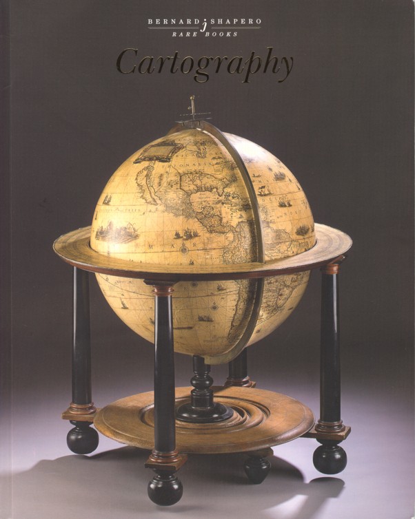
The globe pictured on the catalogue's cover was produced between 1645-1648 by the famed Blaeu family of Amsterdam. This 26-inch diameter globe was produced by Dr. Joan Blaeu during the "golden age" of Dutch mapmaking. The first of these globes was made in 1617 by Joan's father Willem Blaeu. After his death, his son Joan (or Joannes) took over the business, and produced this fourth state of the globe. It was regularly updated to take into account new discoveries. This one covers most of the Americas quite well, but Blaeu cheated to cover his lack of knowledge of the Pacific Northwest by placing a large cartouche over the area. California appears as an island, as it generally would until the next century. The eastern portion of Australia, then known as New Holland, fades off into nothingness. The globe sits on a 17th century Dutch wooden base, and was a very expensive item even at the time. However, not as expensive as it is today. Priced at L500,000 (British pounds, roughly equivalent to US dollars $870,000).
The Blaeu family was particularly known for their atlases, and item 5 was their monumental achievement and the high point of the family's career. Published in 1662, this is the first edition, in Latin, of their 11-volume masterpiece, Atlas Maior (Great Atlas). It contains 591 engraved maps, and numerous other illustrations, colored throughout by a contemporary hand. It has been described as "the greatest and finest atlas ever published." While a Dutch atlas, it contains 58 maps of England and Wales, 25 of America, including important maps of Virginia and New England. The final volume is devoted to the Americas. The price is available on request, which we take to mean this set is not quite as inexpensive as the preceding globe.